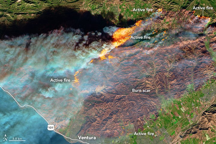
Nearly 110,000 people in Southern California have fled their homes or are under mandatory evacuations as the wildfires that began earlier this week continue to burn mostly-uncontrolled in the area south of Santa Barbara.
1:43am CST #SPC Day1 #FireWX Extremely Critical: portions of southern california https://t.co/OIGmMByFc9 pic.twitter.com/U6LlLrwDIh
— NWS SPC (@NWSSPC) December 7, 2017
The National Weather Service’s Storm Prediction Center warned that wind gusts of 30-40 mph will spread across much of southern California, with gusts that could top out at 80 mph in higher terrains.
At last report, the Thomas Fire near Ventura has burned over 96,000 acres and is 5 percent contained. The California National guard activated two 747 SuperTankers along with several other firefighting aircraft to help drop fire retardant to reduce the spread of the fires.
The flames temporarily closed a section of the 101 Freeway along the coast from Ventura to near Santa Barbara.
An inferno engulfs the Los Angeles region, forcing more than 200,000 people to flee and threatening thousands of homes, including the luxurious Bel-Air neighborhood dotted with mansions https://t.co/hpFMdSbk9j pic.twitter.com/nkcLR141X0
— AFP news agency (@AFP) December 7, 2017
The Creek Fire, which started Monday north of Burbank, has destroyed at least 30 homes and burned over 12,000 acres. As of Thursday morning, it is at 5 percent containment.
The Skirball Fire that broke out near Los Angeles on Wednesday temporarily closed portions of the 405 freeway, a major roadway for millions of people who live in the city.
The Rye Fire, which started Tuesday near Ventura and caused the 101 closure, is 15 percent contained and has burned 7,000 acres.
A string of wildfires in California earlier this summer killed at least 38 people and created over $9.4 billion in insurance claims, according to the California Department of Insurance. Insurers so far have paid out over $2.9 billion for residential property claims. Cal Fire ranks four of those wildfires – the Tubbs, Nuns, Atlas, and Redwood Valley fires – in the list of top 20 most destructive California wildfires in the state’s history.
A GIF from the National Weather Service office in Los Angeles published Wednesday afternoon shows even more dry air forming in Nevada will be pushed south towards Santa Ana and LA on Thursday, contributing to the fire-critical climate.
Latest high resolution smoke dispersion model from 2 AM this morning through 3 AM Friday morning. The dark red indicates heavier smoke. #ThomasFire #CreekFire #SkirballFire #RyeFire #LAfire #cawx #Socal pic.twitter.com/2D8CNUTNDR
— NWS Los Angeles (@NWSLosAngeles) December 7, 2017
Terrifying images of the explosive #ThomasFire which has forced 27,000 people to flee their homes in Southern California.
📷 @reuterspictures @eye4light pic.twitter.com/K5gNyUSHpw— James Cook (@BBCJamesCook) December 5, 2017
At least 110,000 kept away from their homes by Creek fire.
Rye fire evacuations lifted https://t.co/QAMBk5dJGo pic.twitter.com/xj8UxnxmZ0— Los Angeles Times (@latimes) December 6, 2017


